
Derbyshire Maps
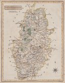
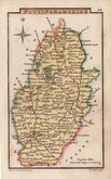
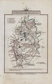
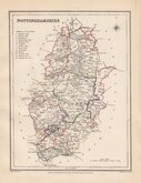
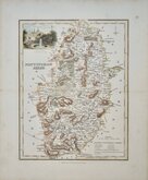
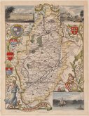
Nottinghamshire Maps
( Page 3 of 4 )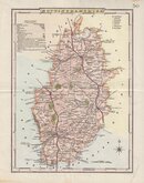
George Cole 1810 [1838]
Samuel John Neele 1818
Sidney Hall 1820
John Cary 1822
Roger Creighton 1831 [1845]
Robert Scott 1833
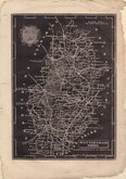
Joshua Archer 1833
Thomas Moule 1837 [1844]


49x38 cm
FINE DUTCH MAP IN ORIGINAL HAND COLOUR.
COMITATUS NOTTINGHAMIENSIS; Sive NOTTINGHAM SHIRE.
Copper engraving by Dutch engraver and publisher, Jan Jansson (1588-1664) issued in his Ioannis Ianssonii Novus Atlas from 1646. Following the publication of a volume of county maps of England and Wales by his rival mapmaker and publisher Jan Blaeu in 1645, Jansson produced his version just one year later matching the superb engraving standard of his rival Blaeu. There were a number of editions of Jansson's work in various languages between 1646 and 1667. Until 1658 the atlas was issued in four or five volumes with the British maps in the fourth volume, later editions expanded to eleven volume with the British map volume numbered variously between four and eight. There were no changes to the map throughout publication.
Jansson's maps often suffer from browning of the paper, especially when in original colour. This example, with Latin text verso, is on good heavy paper with generous margins and in fine original hand colour, is exceptionally clean. The only condition note of mention is a light stain line from an old mount outside the plate edge. A fine map.
Quick Links


Leicestershire Maps

Lincolnshire Maps
×