
Scotland Maps
Northumberland Maps
( Page 1 of 4 )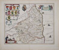
Jan Blaeu 1645
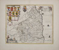
Jan Blaeu 1645 [1664]
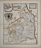
Richard Blome 1673
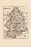
Robert Morden 1695 [1753]
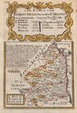
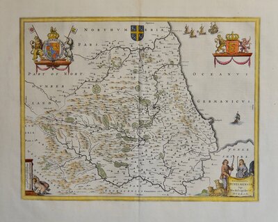
Emanuel Bowen 1720
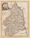
Thomas Read 1743 [1753]
Joseph Ellis 1765 [1773]
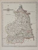
John Cary 1787 [1793]


17x25 cm
UNCOMMON. FINE ORIGINAL HAND COLOUR.
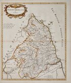
LANGLEY'S new MAP of NORTHUMBERLAND.
Printed and Published by Langley & Belch, No. 173, High street, Borough, London, May 1st.1818.
Copper engraving first published in Langley's new county atlas of England and Wales, embellished with a beautiful vignette to each map...Langley and Belch, 1818. This was the single issue by Langley and Belch, the plates being issued twice more under the same title by Joseph Phelps in 1820.
Edward Langley (fl.1802-1827), engraver, bookseller, publisher and printer, probably born 1771, Henry Langley, Fleet Street weaver and Mary Langley. He was in partnership with William Belch (fl.1805-1843) from 1805-1819 until bankruptcy proceedings ended the partnership. He probably died in 1827 and buried at St. George the Martyr, although his name continued to be listed in directories as a bookseller and printer for some years, the business perhaps continued in the hands of other members of his family. (British Map Engravers Laurence Worms and Ashley Baynton Williams).
Fine example in original hand colour in the first printed state with Langley & Belch imprint.
Ref. Whitaker Maps of Northumberland 352
Quick Links


Cumberland Maps
Durham Maps
×