
Road Maps
Historical Maps
( Page 10 of 10 )

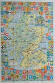
£20 Seige of Sevastopol. Crimea
Ref: 6921
Add to
basket
Thanks,Your Product Has Been Added To Basket

24x36 cm
PAIR OF MAPS FROM THE ILLUSTRATED LONON NEWS.
JAN. 20, 1855] THE ILLUSTRATED LONDON NEWS
MAP OF THE COUNTRY BETWEEN THE RIVER ALMA AND BALAKLAVA, Illustrating the Advance of the ALLIED ARMIES.
(Copyright) DRAWN & ENGRAVED BY J.DOWER, PENTOVILLE, LONDON.
SUPPLEMENT, FEB. 24, 1855.] THE ILLUSTRATED LONDON NEWS
PLAN OF SEBASTOPOL SHEWING THE FORTS & PUBLIC BUILDINGS the Position of THE ALLIED ARMIES IN WINTER QUARTERS AND THE PRESENT STATE OF THE SEIGE WORKS.
DRAWN & ENGRAVED BY J.DOWER, PENTONVILLE, LONDON. (Copyright)
Wood engravings by John Dower (1825-1901) published in the newspaper The Illustrated London News in Jan and Feb 1855 during the Seige of Sevastopol 1854-1855 in the Crimean War.
John James Dower (1825-1901), born in London on 1st January 1825, the son of engraver, publisher and printer, John Crane Dower (1791?-1847). He is recorded as an engraver at the age of 15 on the 1841 census. On the death of his father he inherited the business with his brother Frederick James Dower (1827-1887). He was elected to the Royal geographical society 9th January 1854. He traded ad Dower & Davis in 1859 and John Dower & Co. from 1860 to 1861. Married to Mary Ann Augusta from Clerkenwell, he is recorded on the 1871 Census, living with his wife and three children. He is still recorded as an engraver in in 1891 now a widower, lodging in Wanstead.
The plate showing the Plan of Sebastopol has a 7cm. closed tear at upper centre. Each plate measures approx 24x36cm.
Quick Links


Mediterranean

Europe
×