
Regional Maps of England & Wales
Folding Maps
( Page 8 of 17 )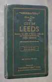
Leeds Geographia 1937
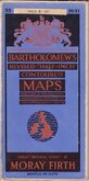
Bartholomew Moray Firth 1940
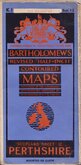
Bartholomew Perthshire 1941
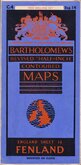
Bartholomew Fenland 1942
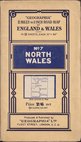
Geographia North Wales 1943
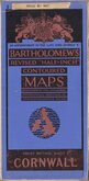
Bartholomew Cornwall 1944

Bartholomew South Yorks and Humber 1944
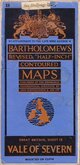
Bartholomew Vale of Severn 1947


96x73 cm
ORDNANCE SURVEY "ONE INCH" MAP
ORDNANCE SURVEY OF GREAT BRITAIN
TRURO & ST. AUSTELL
Fifth Edition, ENGLAND & WALES. SHEET 143
First published by the Director General at the
ORDNANCE SURVEY OFFICE, SOUTHAMPTON, 1934,
with periodical corrected reprints.
Linen backed. Ellis Martin cover.
Condition: Fair. Covers worn, rear cover detached. Some wear at folds.
Quick Links


English Counties

Ordnance Survey Maps
×