
Ordnance Survey Maps
Folding Maps
( Page 7 of 17 )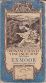
O.S. Exmoor 1934

O.S. Plymouth 1934
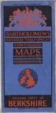
Bartholomew Berkshire 1934
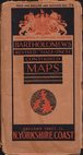
Bartholomew North Yorkshire Coast 1935
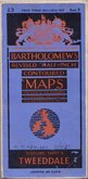
Bartholomew Tweeddale 1937
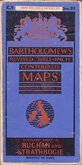
Bartholomew Buchan and Strathbogie 1937
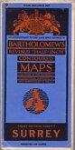
Bartholomew Surrey 1937
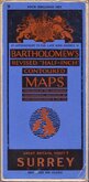
Bartholomew Surrey 1937


85x57 cm
BARTHOLOMEW'S REVISED HALF-INCH MAP
MORAY FIRTH
SCOTLAND, SHEETS 20&21 (L 1)
THE EDINBURGH GEOGRAPHICAL INSTITUTE.
BY APPOINTMENT TO THE LATE KING GEORGE V.
Reduced by permission from the Ordnance Survey with local revision to date of Publication.
COPYRIGHT - JOHN BARTHOLOMEW & SON. LTD.
Cloth backed.
Condition: Very good. Price label to front cover.
Quick Links


English Counties

Regional Maps of England & Wales
×