
Regional Maps of England & Wales
Folding Maps
( Page 5 of 17 )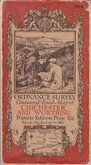
O.S. Chichester Worthing 1920
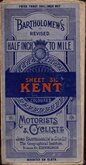
Bartholomew Kent 1922
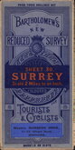
Bartholomew Surrey 1924
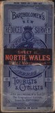
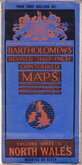
Bartholomew North Wales 1924
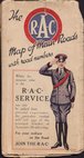
R.A.C. England 1925
Bartholomew North Wales 1929
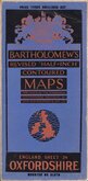
Bartholomew Oxfordshire 1929
Alfred Taylor 1930


72x53 cm
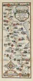
Wexford & Waterford.
Cover title: PRICE TWO SHILLINGS NET BARTHOLOMEW'S NEW REDUCED SURVEY (paper title label missing. Hand written 'SHEET 7 (SE) IRELAND) COLOURED FOR TOURISTS & CYCLISTS JOHN BARTHOLOMEW & CO., The Geographical Instiute. EDINBURGH. MOUNTED ON CLOTH
Map title: SHEET 7. BARTHOLOMEW'S "QUARTER INCH TO MILE' MAP OF IRELAND WEXFORD & WATERFORD. REDUCED BY PERMISSION FROM THE ORDNANCE SURVEY.
Paper printed map pasted on linen in book style card covers, 3 yellow paper advertisements pasted verso.
Slight grubbiness to sea areas on map and lacking pasted paper title to front cover, otherwise good condition.
Quick Links


Ordnance Survey Maps

English Counties
×