
Scotland Maps
Cumberland Maps
( Page 1 of 6 )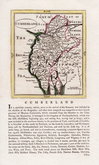
John Seller 1694 [1784]
Robert Morden 1695 [1722]
John Cary 1709 [1805]
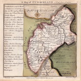
Emanuel Bowen 1720
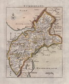
Emanuel Bowen 1720
Thomas Badeslade 1742
Thomas Read 1744 [1753]
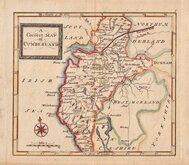
Thomas Hutchinson 1748


12x18 cm
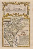
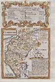
FROM THE "OWEN & BOWEN" POCKET ROAD BOOK BRITANNIA DEPICTA
CUMBERLAND
Map set below a decorative cartouche containing the title and details of the road from Kendal to Cockermouth, &c..
Road map of the first part of the route from Kendal to Keswick verso.
Engraved text descriptions below the county map and alongside and below the road map verso.
Engraved by Emanuel Bowen (1693?-1767) and published in the pocket road book Britannia Depicta by Thomas Bowles from 1720 to 1764. The county maps were based on Robert Morden's small series published in The New Description and State of England... from 1701. Text descriptions compiled by John Owen.
Faint diagonal crease top left corner of road map, less visible top right of title but it remains a very good example in fine hand colour both sides.
For full description of the road, go to category: Maps > British Isles > RoadMaps > Owen & Bowen.
Quick Links


Northumberland Maps

Westmorland Maps
×