
Scotland Maps
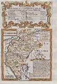
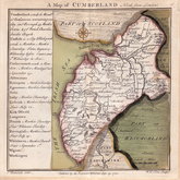
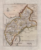
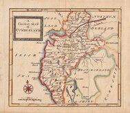
Cumberland Maps
( Page 1 of 6 )
John Seller 1694 [1784]
Robert Morden 1695 [1722]
John Cary 1709 [1805]
Emanuel Bowen 1720
Emanuel Bowen 1720
Thomas Badeslade 1742
Thomas Read 1744 [1753]
Thomas Hutchinson 1748


45x60 cm
CUMBERLAND AND WESTMORLAND ON TWO SHEETS JOINED FROM THE DISPATCH ATLAS ISSUE.
THE DISPATCH ATLAS
CUMBERLAND AND WESTMORLAND BY EDWARD WELLER. F.R.G.S.
Weekly Dispatch Atlas. 139 Fleet Street.
Engraved by Edw.d Weller, 34 Red Lion Square.
Commencing publication in 1859, this series of maps were printed by lithographic transfer from an engraved plate for The Weekly Dispatch Newspaper. The engraving work for the series was shared between Edward Weller, John Dower, and Benjamin Rees Davies. The maps were published in parts issues and when the series was complete, in The Dispatch Atlas in 1863. The publishers Cassell Petter and Galpin acquired the plates publishing them as loose sheets from 1864 and in Cassell's Illustrated family paper and Cassell's British Atlas in 1867. By 1869, the firm of G. W. Bacon had acquired the plates and published them in a number of titles for over forty years.
This map of Cumberland and Westmorland is printed on 2 sheets joined from the Dispatch Atlas issue of 1863.
Some light creasing and tape repair verso to tears top right affecting the map border. Original outline hand colour.
Quick Links


Westmorland Maps

Northumberland Maps
×