
Scotland Maps
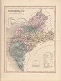
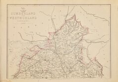
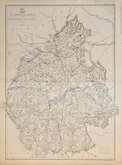
Cumberland Maps
( Page 5 of 6 )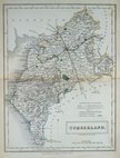
Sidney Hall 1833 [1852]
Roger Creighton 1835
Josiah Neele 1835
Thomas Moule 1837 [1845]
J. & C.Walker 1837 [1850]
Joshua Archer 1842 [1858]
Edward Weller 1862
Edward Weller 1862 [1863]


17x15 cm
UNCOMMON.
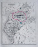
A CORRECT MAP of CUMBERLAND.
Published in Geographia Magnæ Britanniæ. Or, correct maps of all the counties in Engand Scotland and Wales…S.Birt, T.Osborne, D.Browne, I.Hodges, I.Osborne, A.Millar, and I.Robinson, 1748. There was one further issue of the work published by T.Osborne, D.Browne, J.Hodges, A.Miller, J.Robinson, W.Johnston, P.Davey and B.Law, dated 1748 but issued in 1756.
Thomas Hutchinson (fl.1733-1754) signed only two of the maps in the series but it is probable that he was responsible for the engraving all the maps. Hutchinson was born in about 1706, son of Francis Hutchinson, victualler of Fulham. He was apprenticed 6 March 1721 to the engraver, surveyor, mapseller, bookseller, globe maker and instrument seller, John Senex (1678-1740) for 7 years.
The maps were not issued again and are uncommon today.
Quick Links


Northumberland Maps

Westmorland Maps
×