
Scotland Maps
Cumberland Maps
( Page 5 of 6 )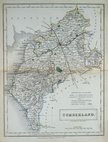
Sidney Hall 1833 [1852]
Roger Creighton 1835
Josiah Neele 1835
Thomas Moule 1837 [1845]
J. & C.Walker 1837 [1850]
Joshua Archer 1842 [1858]
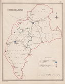
Edward Weller 1862
Edward Weller 1862 [1863]


10x14 cm
2ND EDITION. ORIGINAL HAND COLOUR.
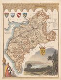
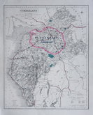
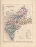
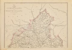
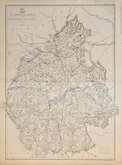
CUMBERLAND
London. Publish’d by J.Wallis, Engraver, 77 Berwick Str. Soho.
Copper engraving by James Wallis, first published in Wallis's new Pocket edition of the English Counties or travellers companion…1812.
James Wallis, Engraver, bookseller, printer, stationer and publisher (fl.1810-1825), has been confused with contemporary bookseller James Wallis (fl.1787-1807) of Ivy Lane and Paternoster Row and with James Wallis, engraver and Jeweller of Fleet Street made bankrupt in 1810. James Wallis, the map engraver was born in 1784 the son of a Bricklayer in Southampton, apprenticed to John Roper in 1799 and had a premises in Berwick Street from 1810-1825. He appears to have ceased engraving in 1825 and is recorded as a commission and discount agent imprisoned for debt in 1835. He became a stationer again trading in Westminster and then, with his son, also James, a dealer in wine and beer.
He produced and published this set of miniature maps together with a larger series in the same year.
Published by Wallis in 1812 & 1814, the maps then briefly became the property of P. Martin followed by Simpkin & Marshall before passing to William Lewis who published them in his Lewis's New Travellers guide… from 1919 to 1836.
This example, with the plate number 4 added top right border, is from the 2nd edition of Wallis's work published in 1814. Brown mark in the blank area of Westmorland probably caused by offsetting from the colour of another map when stacked by the colourist. Original hand colour.
Quick Links


Westmorland Maps

Northumberland Maps
×