
Scotland Maps
Cumberland Maps
( Page 6 of 6 )

20x26 cm
FINE HAND COLOUR.
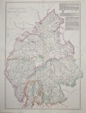
CUMBERLAND.
Published by J.Robins & Co. Ivy Lane, London. January 1.1818
Drawn and engraved by Samuel John Neele, this series were based on John Cary's 'quarto' maps of 1793. The early publication is complex, with loose maps and parts issues for many counties sold by James Cundee from about 1812. The first publication containing the complete set of county maps was The New British Traveller; or, modern panorama of England and Wales...By James Dugdale... published about 1819 by J & J Cundee. The maps appeared in three further issues with the imprint of J. Robins & Co. under various titles.
Samuel John Neele (1758-1824) was a prolific engraver working from Russell Court from 1781 and 352 Strand from 1785-1824. He traded with his younger brother George Neele as “S.& G. Neele” 1826-1824 and with his son James Neele as “Neele & Son” 1816-1824.
Small right margin, edged with matching contemporary paper. Fine hand colour.
Quick Links


Northumberland Maps

Westmorland Maps
×