
Scotland Maps
Cumberland Maps
( Page 5 of 6 )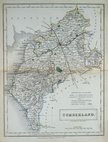
Sidney Hall 1833 [1852]
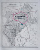
Roger Creighton 1835
Josiah Neele 1835
Thomas Moule 1837 [1845]
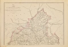
J. & C.Walker 1837 [1850]
Joshua Archer 1842 [1858]
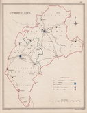
Edward Weller 1862
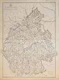
Edward Weller 1862 [1863]


15x20 cm
FROM A REGENCY SCHOOL ATLAS. ORIGINAL COLOUR. UNCOMMON.
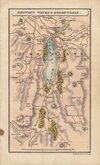
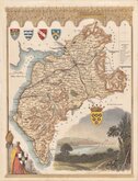
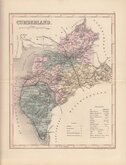
CUMBERLAND
Lithographic transfer from Reuben Ramble's regency school atlas, Travels through the Counties of England published by Darton & Clark (and Darton & Co.) between 1845 an 1850. Reuben Ramble was the pseudonym of Reverend Samuel Clark.
The small map was first issued, printed from the copperplate, in a set of playing cards by Thomas Crabb c.1819, followed by Miller's New Miniature Atlas... Robert Miller, 1821, and Darton's New Miniature Atlas...William Darton, 1822 & 1825.
Good example in original hand colour with original typeset text description of the county.
Uncommon.
SPECIAL OFFER MOUNT AVAILABLE AT CHECKOUT FOR UK DELIVERY.
Quick Links


Northumberland Maps

Westmorland Maps
×