
Town Plans
Central London
( Page 1 of 1 )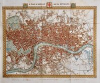
Roger Creighton 1831
G W Bacon London. 1910
Joseph Scheda 1845
Bacon G W 1900
Kelly's Post Office 1904
Bacon, G. W. 1900


48x40 cm
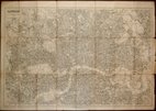
A PLAN of LONDON and its ENVIRONS.
DRAWN BY R. CREIGHTON | ENGRAVED BY J. & C. WALKER.
DRAWN AND ENGRAVED FOR LEWIS' TOPOGRAPHICAL DICTIONARY.
Copper engraving by brothers John Walker (1790?-1873) and Charles Walker (1799?-1872) trading as “J & C Walker” from about 1827. John Walker is known for his work for James Horsburgh and the East India Company as well as his work for the Admiralty and leading publishers of the period. He was founder member of the Royal Geographical Society in 1830.
Drawn by Roger Creighton (1796-1838) draughtsman and surveyor. Born at Tynemouth, he is first recorded as a land-surveyor in Wakefeld and perhaps trained under Christopher Greenwwod with whom he worked on his series of county maps from 1818. He married Martha Gostling 16 Jan 1823 at St George Hanover Square and is variously recorded as draughtsman or surveyor on the baptismal records of their children between 1824 and 1834. He became the principal draughtsman for the Topographical Dictionary by Samuel Lewis.
Published in A Topographical Dictionary of England…Samuel Lewis and Co. from 1831. The work achieved considerable success and was re-issued many times by Lewis until 1849. During this time the maps were regularly updated to include parliamentary and electoral information and changes to the rapidly expanding railway network.
Good example from the first edition showing both old and new London bridges published in 1831. Folds as issued. Closed tear into the border at the upper left margin just reaching the map. Some light spotting to margins & verso. Fine detailed later hand colour.
Howgego ref. 330 (1)
Quick Links

Ward Plans and Parts of London

Environs of London
×