
Buckinghamshire Maps
Bedfordshire Maps
( Page 3 of 4 )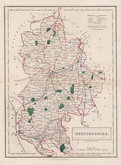
Sidney Hall 1830 [1846]
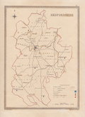
Roger Creighton 1831
Roger Creighton 1831
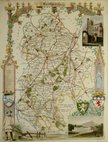
Gray & Son 1833
Joshua Archer 1833
Roger Creighton 1835
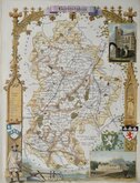
Thomas Moule 1836 [1852]
Thomas Moule 1836 [1852]


19x25 cm
RARE UNRECORDED INTERMEDIATE ISSUE
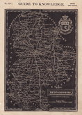
BEDFORDSHIRE
ENGRAVED BY SIDY. HALL
London Published by Chapman & Hall 186, Strand.
This series of maps first appeared in Gorton's Topographical Dictionary issued in parts over a three year period from 1830, the complete work not published again after 1833. The maps were then issued in A New British Atlas…, Sidney Hall's British Atlas…, A Travelling County Atlas… and other variations on the title, from 1834 until c.1888. It's popularity due in part to Hall's continuous updating of the plates to include the latest railways. The maps were intaglio printed until c.1858 and then by lithographic transfer.
Good example in original hand colour including the addition of the GNR and the E & BR from Bedford to Tempsford as recorded in Chambers Printed Maps of Bedfordshire ref. 83 (vii) except that the GNR is not named and the railways are hand coloured blue not red. Close examination reveals that the GNR and the Bedford to Tempsford link are not engraved on the plate but are coloured blue in the same original colouring hand, revealing this as an intermediate issue between (vii) and (viii), or possibly as an amendment to use up printed plates to match the re-engraved and updated plates, but given that the colouring to the lines here is blue and not red as all recorded issues, it would suggest that the former intermediate issue is most likely.
Betty Chambers Printed maps of Bedfordshire Ref. 83 (vii) - (viii) see note above.
Quick Links


Berkshire Maps
Bedfordshire Prints
×