
Berkshire Maps
Bedfordshire Maps
( Page 2 of 4 )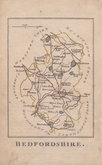
Robert Butters 1803
Cole & Roper 1804
Henry Cooper 1808
John Cary 1809
Samuel John Neele 1814
Sidney Hall 1820
John Cary 1824
Aristide Perrot 1824


9x13 cm
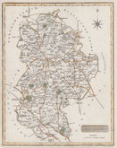
BEDFORDSHIRE.
RARE "UPSIDE-DOWN" SERIES
The engraver or engravers of this series of maps are unknown and the maps are known by the first publisher, Robert Butters, a Fleet Street printer, who issued them in An Atlas of England... in 1803. They are also referred to as the "upside-down series" as the England map and many of the county maps are engraved with North to the bottom of the page. In fact, the county maps are variously orientated with North to the top, left, right or bottom of the page. The work was possibly intended for school use and the odd orientation of the maps may have been done to appeal to young minds. This represented Robert Butters' only serious venture into cartography but unlike the huge success of John Cary's publication The Traveller's Companion, on which these maps were based, Butter's publication was limited to this single issue. John Hatchard acquired the plates later the same year issuing them in a two-volume work The Picture of England 1803, and 1804. The publications were small and only a single copy of the 1803 edition has been found.
This map of Bedfordshire, in keeping with the tradition of the series is orientated with North to the bottom. No compass rose. Overall toning, otherwise a good example from the first issue of 1803 (although the issues were unchanged) in original had colour. Rare.
Betty Chambers Printed Maps of Bedfordshire Ref. 56
Quick Links


Buckinghamshire Maps
Bedfordshire Prints
×