
Yorkshire North Riding
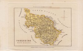
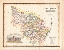
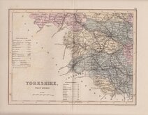
Yorkshire West Riding
( Page 3 of 3 )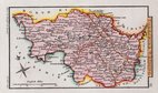
Sidney Hall 1820 [1834]
Samuel Tymms 1822 [1837]
James Neele 1833
Thomas Moule 1837
Joshua Archer 1842 [1858]
Smith & Moss 1903

£185
Emanuel Bowen John Tinney Ref: 6506wH
Add to
basket
Thanks,Your Product Has Been Added To Basket

71x53 cm
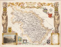
LARGE ENGLISH ATLAS. RARE TINNEY IMPRINT.
An ACCURATE MAP of the WEST RIDING of YORK SHIRE, Divided into its WAPONTAKES. Drawn from Surveys, with various additional Improvements: ILLUSTRATED with HISTORICAL EXTRACTS relative to its Natural Produce, Mines, Minerals, Manufactures, Trade and the present state of its Principal Towns.
By Eman.l Bowen Geographer to HIS MAJESTY.
Sold by I.Tinney at the Golden Lyon in Fleetstreet London 1753.
Dedication to Thomas Wentworth Marquis of Rockingham. Bottom right.
A View of Leeds. Based on the engraving by Samuel and Nathaniel Buck. Top right.
Copper engraving by Emanuel Bowen (1693?-1767) published in The Large English Atlas from 1760. The work was the first large scale atlas of English counties since the works of Blaeu and Jansson a century earlier. The maps were based on the latest surveys available and were a long time in preparation, beginning in 1749 with the county of Sussex and reaching completion of 45 plates in 1760. Yorkshire and the Ridings were issued in 1750. The engraving work was shared between Thomas Kitchin (1719-1784) and Emanuel Bowen. The project, begun by John Hinton (1716-1781), passed through the hands of several publishers and were issued individually and in part works without title. The main publication for the maps, The Large English Atlas was issued by various publishers until c.1794 with various imprints but very few changes to the maps.
The engraver of this West Riding map, Emanuel Bowen (1693?-1767) was born in Wales, the son of Owen Bowen, gentleman, of Talley, Carmarthen and his wife Anne. He worked in London from about 1720 to 1767 and was very prolific, engraving plates for many important works including Britannia Depicta, A Complete System of Geography, the London and Universal magazines, Harris' Complete Collection of Voyages, Universal History of the World and many of the maps in The Large English Atlas, The Royal English Atlas and Atlas Anglicanus. He was appointed engraver of maps to George II and Louis XV. His daughter Sarah married his apprentice Thomas Kitchin (1719-1784) who worked with Emanuel Bowen on many works including this, The Royal English Atlas. Emanuel Bowen died aged about 74 "reduced by family extravagances, and almost blind through age" (Gough).
This example has the imprint of John Tinney (1706-1761) engraver, printseller, mapseller and publisher, who purchased the stock of maps and plates from John Hinton in 1752 or 1753 to take over and complete the series of large county maps that Hinton began in about 1748. Hodson (County Atlases of the British Isles vol.2 p.138) records that Tinney's imprint on the map of the West Riding is found in only a single copy of the work, held in Cambridge University Library and this being an additional map inserted into the volume.
Original colour to the map and later colour to the decorative elements. Several tears to the paper edges, particularly top edge, repaired verso with archival tape and tissue, some extending into, but not beyond, the map border. Otherwise, good heavy paper with reasonable margins and a very rare issue with the Tinney imprint dated 1753.
Ref. Whitaker Printed Maps of Yorkshire [211]
Hodson County Atlases of the British Isles 221
Quick Links


Yorkshire East Riding

Whole of Yorkshire
×