
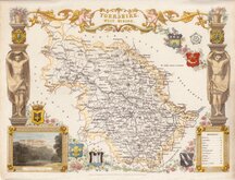
Whole of Yorkshire
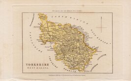
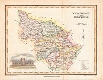
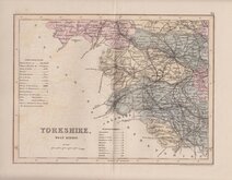
Yorkshire West Riding
( Page 3 of 3 )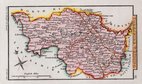
Sidney Hall 1820 [1834]
Samuel Tymms 1822 [1837]
James Neele 1833
Thomas Moule 1837
Joshua Archer 1842 [1858]
Smith & Moss 1903


11x7 cm
SCARCE MINIATURE MAP.
YORKSHIRE WEST RIDING
Miniature map published by John Bowyer Nichols and Son in The Family Topographer: being a compendious account of the antient and present state of the counties of England. By Samuel Tymms.
This series of maps are first recorded in a single copy of Crosby's Complete Pocket Gazetteer of England and Wales published in 1822 and later appeared in A Compendium of the Ancient and Present state of…(various circuits) 1831-1837, The Family Topographer 1831 -1837 and Camden's Britannia Epitomized..1842.
The map has no scale bar but includes distances of the major towns from London. The map is dated 1838 but the title page of the work was dated 1837.
A scarce map in very good condtition.
Ref. Whitaker Printed Maps of Yorkshire [442]
Quick Links


Yorkshire East Riding

Yorkshire North Riding
×