
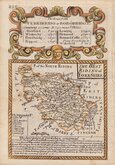
Yorkshire East Riding
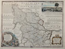
Yorkshire West Riding
( Page 1 of 3 )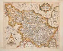
William Hole 1607 [1610]
Jan Jansson 1646
Robert Morden 1695
Robert Morden 1695 [1730]
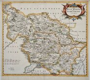
Emanuel Bowen 1720
Kitchin & Jefferys 1749
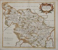
Emanuel Bowen 1750 [1753]
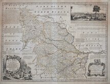
Emanuel Bowen 1750 [1763]


42x36 cm
FIRST TO SHOW LONGITUDE FROM LONDON AND IN BOTH DEGREES AND LOCAL TIME.
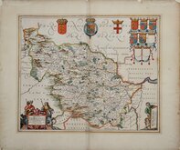
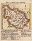
THE WEST RIDING of YORKSHIRE
by Rob:t Morden.
Sold by { Abel Swale Awnsham and Iohn Churchill.
Copper engraving produced by Robert Morden for publication in Edmund Gibson's translation of William Camden's Britannia first published by Abel Swalle and Awnsham & John Churchill in 1695.
This is the first series of maps to mark longitude in minutes of time from London (top border) as well as in degrees (bottom border). Minutes of time was useful during a period when time was not yet standardised across the country. For most counties longitude is based on the meridian of St. Paul's, London. For most maps in the series, but not the East and West Ridings of Yorkshire, they were the first folio county maps to show roads, Morden making use of the survey and strip road maps of John Ogilby published in his road book, also entitled Britannia, in 1675. Morden did not however, adopt John Ogilby's standardisation of measure for the mile at 1760 yards preferring the somewhat arbitrary method of including three scales according to varying local measurement, of 'Great', 'Middle' and 'Small' miles.
The work was republished in 1722, 1730, 1753 and, finally in 1772. The West Riding map was unchanged in all editions but the plate was reworked for the 1753 edition due to wear.
Very good hand coloured example from the 1730 edition identified by the "Spread Eagle" watermark.
Ref. Whitaker Printed Maps of Yorkshire [139] (1730 edition not listed).
Quick Links


Yorkshire North Riding

Whole of Yorkshire
×