
Yorkshire East Riding
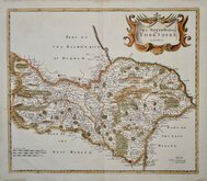
Yorkshire North Riding
( Page 1 of 3 )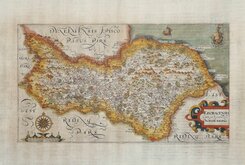
William Hole 1607
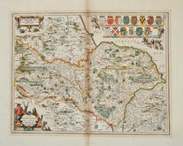
Jan Jansson 1646
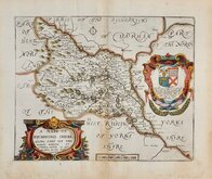
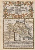
Richard Blome North Riding 1673
Richard Blome Richmondshire 1673
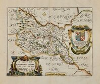
Richard Blome Richmondshire 1673
Robert Morden 1695 [1722]
Emanuel Bowen 1720
Emanuel Bowen 1763 [1777]

£18
Joshua Archer John Tallis Ref: 4633gt
Add to
basket
Thanks,Your Product Has Been Added To Basket
Request
Condition Report
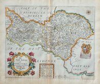
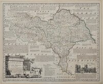
EASTERN PART OF THE RIDING.
YORKSHIRE, NORTH RIDING &c.
Drawn & Engraved by J. Archer, Pentonville, London.
First published in Curiosities of Great Britain, England and Wales Delineated…by Thomas Dugdale by L.Tallis in 1842. The work was re-issued a number of times until 1860. The maps also appeared in The Universal English Dictionary…by the Rev. James Barclay and finally in Tallis's topographical dictionary of England & Wales in 1860.
Joshua Archer (c.1792-1863) Engraver, cartographer and copperplate printer, was born in Barnstaple in Devon. His first recorded work as an engraver was a map of Scotland for Robert Wilkinson in 1814. He was declared bankrupt in 1835, imprisoned for debt in 1845, but on the 1861 census, he is recorded as a map and chart engraver aged 69, living in Islington with his wife Jane, a son, John, also a map and chart engraver, Albert Archer, map and chart draughtsman, Albert’s wife Elizabeth and their three children. His death was recorded at Islington in the final quarter of 1763.
This map, showing the eastern part of the North Riding, includes the addition of several railways and was published c.1848. Original hand colour.
Ref. Whitaker Printed Maps of Yorkshire [493]
Quick Links


Yorkshire West Riding

Whole of Yorkshire
×