
Yorkshire West Riding
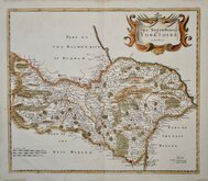
Yorkshire North Riding
( Page 1 of 3 )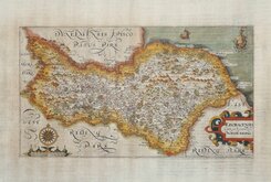
William Hole 1607
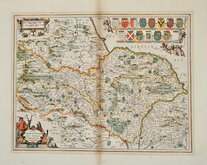
Jan Jansson 1646
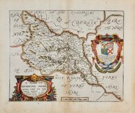
Richard Blome North Riding 1673
Richard Blome Richmondshire 1673
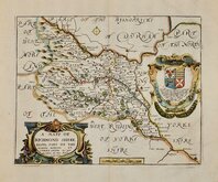
Richard Blome Richmondshire 1673
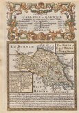
Robert Morden 1695 [1722]
Emanuel Bowen 1720
Emanuel Bowen 1763 [1777]

£18
Cole Vernor, Hood & Sharpe Ref: a6028.21
Add to
basket
Thanks,Your Product Has Been Added To Basket

23x18 cm
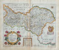
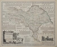
"COLE & ROPER" EASTERN PART OF THE RIDING.
YORKSHIRE: NORTH RIDING &c.
Engraved by J. Roper from a Drawing by G. Cole.| to accompany the Beauties of England and Wales.
London: Published for the Proprietors, by Vernor, Hood & Sharpe, Poultry Jan.y.2.1809.
Engraved by John Roper (1771-1810), a London engraver and copperplate printer trading from New Street Square from 1797 until his death in 1810. His widow, Mary Roper, continued the business at the same address until at least 1846. This series of maps, most drawn by G[eorge?] Cole, were intended to accompany The Beauties of England and Wales. The maps were not actually published with this work but first issued in parts as a separate series between 1804 and 1810 and first appearing in atlas form in The British Atlas published by Vernor Hood & Sharpe (& nine other publishers) in 1810. The maps were re-issued in several publications including Dugdale's Curiosities of Great Britain until 1843. Their final appearance was by lithographic transfer in Collins' railway and pedestrian atlas… published by Darton and Co. in 1858.
Later red underlining to some place names otherwise good example in original hand colour from the first edition of 1810.
Ref. Whitaker Printed Maps of Yorkshire [310]
Quick Links


Whole of Yorkshire

Yorkshire East Riding
×