
Yorkshire West Riding
Whole of Yorkshire
( Page 1 of 4 )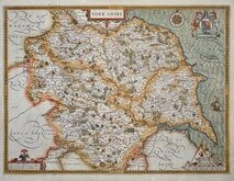
John Speed 1610 [1627]
Jan Jansson 1646
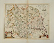
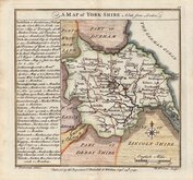
Richard Blome 1673
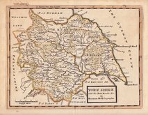
John Seller 1694
John Seller 1694 [c.1784]
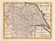
Herman Moll 1724 [1753]
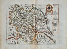
Badeslade, Thomas 1741
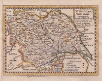
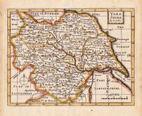
John Cowley 1743


18x13 cm
UNCOMMON.
An Improved MAP of YORK SHIRE containing the Borough and Market Towns, with those adjoyning; also its Principal Roads and Rivers. by J. Cowley Geog.r to his MAJESTY
The first six county maps in this series were published by Robert Dodsley (1703-1764) in The publick register: or, the weekly magazine. The magazine ran for only twenty-four numbers from January to June 1741, the 6 maps (Beds, Berks, Bucks, Cambs Cheshire & Cornwall), with accompanying historical and geographical description, appearing between 14th March and 6th June.
Dodsley decided to complete the series and published the maps and descriptions in a separate publication The Geography of England: Done in the manner of Gordon's geographical grammar...To each county is prefix'd a compleat mapp from the latest and best observations...London, R. Dodsley, 1744. (Actually published November 1743.)
The maps were re-issued in an atlas without the county descriptions in A New Sett of pocket mapps of all the counties of England and Wales ... London: Printed for R. Dodsley in Pall mall, and M. Cooper in Pater-noster Row. 1745. The Yorkshire map was unchanged in both editions.
Small left border re-margined in matching paper. Later hand colour. Uncommon.
ref. Whitaker Printed Maps of Yorkshire [189]
Quick Links


Yorkshire East Riding

Yorkshire North Riding
×