
Bedfordshire Maps
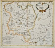
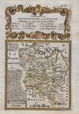
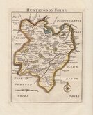
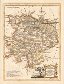
Huntingdonshire Maps
( Page 1 of 5 )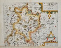
William Kip 1607 [1637]
Michael Drayton 1622
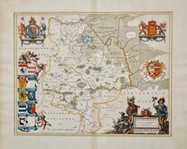
Jan Blaeu 1645
John Seller 1694 [c.1784]
Robert Morden 1695
Owen & Bowen 1720
Thomas Read 1744 [1769]
Thomas Kitchin 1763


22x36 cm
FIRST MAP OF THE COUNTY ENGRAVED ON STEEL. INCLUDING ORIGINAL PAGE OF TEXT.
HUNTINGDONSHIRE.
Engraved on Steel by Pigot & Son Manchester.
Published by Pigot & C.o 59 Fleet Street. London & Fountain S.t Manchester.
James Pigot produced the first National Directory and the maps that accompanied his directories represented a technological advance in printing, being engraved on a steel plate rather than copper. The ability to engrave on steel extended the useable life of the plate, being less vulnerable to wear during the printing process. The engraver could also produce finer lines and therefore more detail; it is possible that Pigot included a finely detailed vignette on each map to demonstrate this quality achievable with the new technology.
This series of maps were first issued in parts from about 1826, beginning with the home counties and first appearing complete in atlas form in 1830. Production continued under various titles by Pigot and his partner and successor, Slater until 1857.
Includes vignette of Godmanchester Church. With original page of typeset text description of the county.
Fine example from the 1939 edition from Pigot & Co's British Atlas...in original hand colour.
Quick Links


Northamptonshire Maps

Cambridgeshire Maps
×