
Cambridgeshire Maps
Huntingdonshire Maps
( Page 5 of 5 )

11x18 cm
ALSO KNOWN AS "CAPPER" OR "WHITAKER" MAPS.
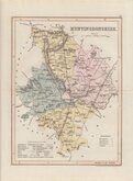
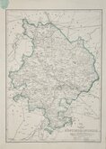
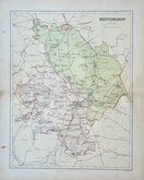
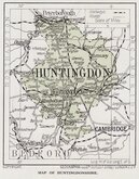
HUNTINGDON
Published by G & W.B.Whittaker, 13, Ave Maria Lane, 1824.
Copper engraving by Henry Cooper first published A Topographical Dictionary of the United Kingdom...Accompanied by Forty-Six maps, Drawn Purposely For This Work, On An Original Plan. By Benjamin Pitts Capper...Richard Phillips 1808.
There were several later publications of the same work by various publishers until 1839.
Good hand coloured example in the final state of the plate published from 1825 until 1839.
Quick Links


Northamptonshire Maps

Bedfordshire Maps
×