
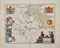
Bedfordshire Maps
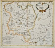
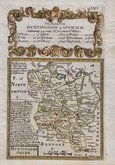
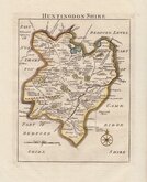
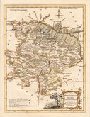
Huntingdonshire Maps
( Page 1 of 5 )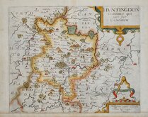
William Kip 1607 [1637]
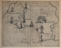
Michael Drayton 1622
Jan Blaeu 1645
John Seller 1694 [c.1784]
Robert Morden 1695
Owen & Bowen 1720
Thomas Read 1744 [1769]
Thomas Kitchin 1763


31x43 cm
FROM THE WEEKLY DISPATCH NEWSPAPER
THE DISPATCH ATLAS
B R DAVIES
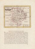
HUNTINGDONSHIRE
BY JOHN DOWER, F.R.G.S.
Weekly Dispatch Atlas, 139 Fleet Street. | Engraved by Dower & Davis, 28 Ludate Street, St Pauls.
Day & Son Lith.rs to The Queen.
[Embossed stamp upper left corner]:
SUPPLEMENT TO THE WEEKLY DISPATCH OF SUNDAY FEB.Y 20TH 1859.
Commencing publication in 1860, this series of maps were printed by lithographic transfer from an engraved plate, the plates were not used for direct intaglio printing. The first publication was in the Weekly Dispatch Newspaper between 1856 and 1862, followed by loose sheet issues and, when the series was complete, in The Dispatch Atlas in 1863. The publishers Cassell Petter and Galpin acquired the plates and published them in Cassell's Illustrated family paper and Cassell's British Atlas in 1867, By 1869, the firm of G. W. Bacon had acquired the plates and published them in a number of titles for over forty years.
A very good example from the first issue in original hand colour.
Quick Links


Northamptonshire Maps

Cambridgeshire Maps
×