
Essex Maps
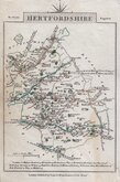
Hertfordshire Maps
( Page 5 of 11 )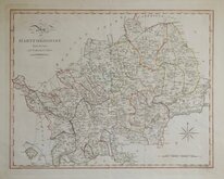
John Cary 1789 [1805]
John Cary 1791
Francis Vivares 1794
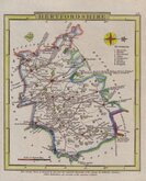
John Stockdale 1798
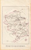
Robert Butters 1803
Cole & Roper 1805
John Cary 1806
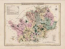
Charles Cooke 1806 [c.1824]


46x35 cm
UNCOMMON.
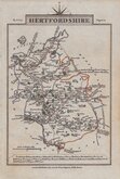
HERTFORDSHIRE.
Drawn under the superintendance of T.L.Murray. | Hoare & Reeves sc.
London. Published May 1st.1832, by T.L.Murray, 19, Adam Street, Adelphi.
The map is a close copy of William Ebden's map of 1825 engraved by the same firm, Hoare & Reeves, Edward Hoare (fl.1822-1840) and James Reeves (1801?-1868). T. Laurie Murray FRGS, London publisher and surveyor, published the maps in his Atlas of the English Counties divided into hundreds &c....projected on the basis of the trigonometrical survey by order of the Honble,, the Board of Ordnance. Under the superintendance of T.L.Murray. in 1830, 1831 and 1832. The Hertfordshire map was later published by William Robson and Co. in Robson's...commercial directory of London and the six home counties... London 1838 and 1839.
This example in original hand colour is from the 3rd edition of Murray's atlas
Some overall toning. No centrefold. Uncommon.
Ref. Hodson Printed Maps of Hertfordshire. 90 (iii).
Quick Links


Middlesex Maps

Hertfordshire Prints
×