
Essex Maps
Hertfordshire Maps
( Page 7 of 11 )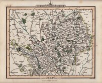
Charles Smith 1822 [c.1829]
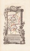
Aristide Perrot 1824
William Ebden 1825 [c.1833]
Herman Moll 1826
James Pigot 1826 [1846]
Joseph Cross 1827
Joseph Cross 1827
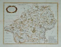
T L Murray 1830 [1832]


Request
Condition Report
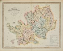
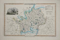
LARGE MAP. FINE VIGNETTE OF ST ALBANS ABBEY.
MAP of the County of HERTFORD, from an Actual Survey made in the Years 1830 & 1831. BY C. & J. GREENWOOD. Published by the Proprietors GREENWOOD & CO. 3, Burleigh Strt. Strand. LONDON. Corrected to the present period. and published April 1st. 1834. Engraved by J. & C. Walker.
The Greenwoods had planned to produce a set of new surveys of the English counties at an inch to a mile with the claim that they were to be based on new surveys. There is doubt about this claim, the maps appearing to be based on Ordnance survey and other sources but even so, finances were stretched and although an advertisement appeared about 1830 for a full set of English counties at 125 guineas, six counties were not actually completed and their business appears to have ceased trading. This set of reduced versions of their maps, published in The Atlas of the counties of England, from actual surveys made from the years 1817 to 1833, by C & J Greenwood. in 1834., were issued from the premises of John & Charles Walker, the firm initially employed, among others, by the Greenwoods as engravers.
Vignette of St Alban’s Abbey.
Good example in original hand colour. Archival tape to short centrefold splits top & bottom, otherwise undamaged with good margins. Some offsetting from the large vignette and title.
Ref. Hodson Printed Maps of Hertfordshire. 100
Quick Links


Hertfordshire Prints

Middlesex Maps
×