

Staffordshire Maps
Derbyshire Maps
( Page 4 of 4 )

31x44 cm
WEEKLY DISPATCH FIRST ISSUE
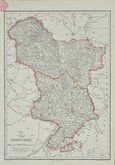
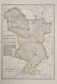
DERBYSHIRE
Weekly Dispatch Atlas, 139, Fleet Street.
Drawn & Engraved by John Dower, Pentonville, London.
This series of maps were printed by lithographic transfer from engraved plates by Edward Weller, John Dower and Benjamin Rees Davies. The plates were never used for direct intaglio printing. The first publication was in the Weekly Dispatch Newspaper between 1856 and 1862, followed by loose sheet issues and, when the series was complete, in The Dispatch Atlas in 1863. The publishers Cassell Petter and Galpin acquired the plates and published them in Cassell's Illustrated family paper and Cassell's British Atlas in 1867, By 1869, the firm of G. W. Bacon had acquired the plates and published them in a number of titles for over forty years.
This map was engraved by John James Dower (1825-1901), son and successor to engraver John Crane Dower (1791?-1847) and is from the first issue published in the Dispatch atlas with the embossed coloured stamp of the Weekly Dipatch Supplement for Sunday May 23rd 1859. Original hand colour. The map has very light unobtrusive central vertical and horizontal folds.
Quick Links


Nottinghamshire Maps

Leicestershire Maps
×