
Road Maps
Buckinghamshire Maps
( Page 2 of 4 )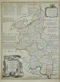
Emanuel Bowen 1760 [1765]
George Rollos 1763 [1769]
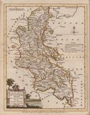
William Palmer 1765 [1773]
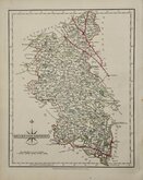
John Cary 1787 [1793]
John Haywood 1788
Robert Butters 1803
George Cole 1804
Sidney Hall 1820


22x30 cm
UNCOMMON.
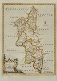
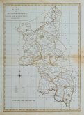
An ACCURATE MAP of BUCKINGHAM-SHIRE, Divided into its HUNDREDS, By G.Rollos, Geog.r
Engraved by George Rollos (1731-1796), and first published in The British Magazine or Monthly Repository for Gentlemen and Ladies...Volume IV...James Fletcher, London, September 1763. The county maps were published in the magazine in alphabetical order from March 1972, suggesting that a complete set of county maps of England and Wales were envisaged for the publication, but only five maps were completed; Anglesey, Bedfordshire Berkshire, Brecknockshire and Buckinghamshire. All the maps are based on the maps from Bowen & Kitchin's Large English Atlas of 1760.
George Rollos was apprenticed to engraver, cartographer and publisher, Thomas Kitchin (1719-1784). He seems to have remained a close friend and associate of Kitchin, following his move to St. Albans in 1780 and witnessing his will in that year.
All the maps, except Bedfordshire, were issued once more, in England Displayed. Being A New, and Accurate Survey and Description of the Kindom of England and Principality of Wales...London 1769.
This example, with the imprint outside the top border for the British Magazine removed, is from England Displayed.
Small right margin but a fine example in neat later hand colour.
Quick Links


Bedfordshire Maps

Berkshire Maps
×