
Far East & India
Middle East
( Page 6 of 6 )
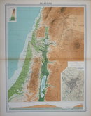
£15 Palestine by Bartholomew
Ref: 1311.52
Add to
basket
Thanks,Your Product Has Been Added To Basket

42x56 cm
PALESTINE
Large double page colour printed lithograph by John Bartholomew & Son Ltd. published in The Times Atlas and Gazetteer of the World by The Edinburgh Geographical Institute 1922.
Detailed inset plan of JERUSALEM and Section through JUDEA and the DEAD SEA at the bottom of the map.
Quick Links

Eastern Europe & Turkey

Mediterranean
×