
Yorkshire Maps
Durham Maps
( Page 4 of 4 )

32x22 cm
FROM ATLAS ANGLICANUS.
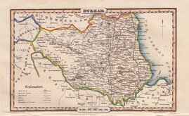
DURHAM, Divided into Wards; ~ Describing the ~ City, Market Towns &c. with concise Historical Extracts, relative to its Natural Produce, Trade & Manufactures; Distinguishing also the Church Livings, with Improvements not inserted in any other Half Sheet County Maps Extant. By Eman: Bowen. Geogr. to his late Majesty & Thos. Bowen.
First published in Atlas Anglicanus in 1767, this series of maps were based on the large maps produced for the Large English Atlas by Thomas Kitchin and Emanuel Bowen from about 1749. Various publishers were involved in the troubled and expensive production of the large maps and the subsequent productions of smaller maps in the Royal English Atlas and Atlas Anglicanus were attempts at recouping some of the expenses incurred for the original surveys and publication.
It is noted in the title that Emanuel Bowen’s son, Thomas, worked with him on this, his final work, the publication of which coincided with Emanuel’s death in 1767.
Neither of the smaller derivatives achieved the sales success made by the Large English Atlas and surviving examples are uncommon.
There were three issues of the map with the decorative rococo title cartouche in 1767, 1770 and 1777. The plates were then acquired by Thomas Bowles who erased the title, replacing it with a simple oval title panel and published them in his New Medium Atlas in 1785 with individual county maps being offered for sale until at least 1798.
Some browning from an old mount verso including some old tape stains (tape now removed), which has affected the face of the map at the borders, the main area of the map is unaffected. The hand colouring is of some age and the map remains very presentable especially mounted as the option offered at checkout.
SPECIAL OFFER MOUNT OPTION AVAILABLE AT CHECKOUT FOR UK CUSTOMERS.
Quick Links


Northumberland Maps
Durham Prints
×