
Westmorland Maps
Cumberland Maps
( Page 4 of 6 )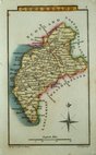
Sidney Hall 1820
W. H. Reid 1820
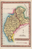
John Cary 1822
John Cary 1822
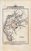
Roger Creighton 1831 [1842]
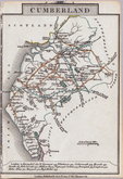
Joshua Archer 1833
William Ebden 1833
Robert Scott 1833 [1840]


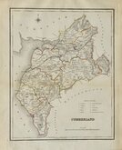
7x12 cm
COLOURFUL MINIATURE MAP
CUMBERLAND.
Pub. by S. Leigh 18, Strand. | Sid.y Hall sculp.t
Miniature map engraved by Sidney Hall and first published by Samuel Leigh in Leigh's New Pocket Atlas of England and Wales in 1820. The demand for pocket atlases for the traveller was high during the first half of the 19th century and this little atlas, Samuel Leigh's only cartographic work, was very popular, running to three editions with a further eight editions after his death by his widow Mary Ann and then his son until 1839. The plates were then acquired by George Biggs who published two more editions until 1843.
Sidney Hall (1788?-1831), began work as an engraver about 1809 and was in partnership with Michael Thomson (fl.1809-1815) as "Thomson & Hall" in 1814. Hall was a pioneer of engraving on steel and is almost certainly the first engraver to use steel plates for map engraving, producing steel engraved maps from 1821. He married Selina Price in 1821 but died early in 1831 aged forty-two. Selina carried on his engraving business signing her maps "S. Hall" which has caused some confusion in map bibliographies.
Fine hand coloured example from the first edition.
SPECIAL OFFER MOUNT OPTION AVAILABLE ON THIS ITEM AT CHECKOUT FOR UK CUSTOMERS.
Quick Links


Scotland Maps

Northumberland Maps
×