
Northumberland Maps
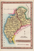
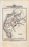
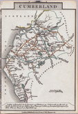
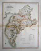
Cumberland Maps
( Page 4 of 6 )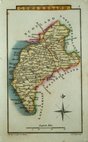
Sidney Hall 1820
W. H. Reid 1820
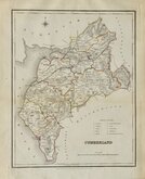
John Cary 1822
John Cary 1822
Roger Creighton 1831 [1842]
Joshua Archer 1833
William Ebden 1833
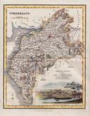
Robert Scott 1833 [1840]


51x41 cm
STOCKDALE EDITION.
A MAP of CUMBERLAND from the best AUTHORITIES.
Published by John Stockdale Piccadilly 26th.March 1805.
Engraved by J.Cary.
Copper engraving by John Cary. The maps were first issued in parts by T. Payne & Son, and G.G.J. & J. Robinson for Richard Gough's translation of William Camden's Britannia, the completed work being published in 1789. Following the death of Payne, the Robinson family sold the plates and publication rights to John Stockdale. Richard Gough was reportedly annoyed with the new arrangements and refused to work on the new edition and Stockdale completed the editorial work himself, expanding the work to four folio volumes and publishing them in 1806. Stockdale also used the plates in his New British Atlas from 1805 to 1809.
This example of the county of Cumberland is from the Stockdale edition of 1805. The county is orientated with North-West to the top of the page, the longitude and latitude divisions in the border indicating this orientation, the compass rose however, is engraved incorrectly showing North to the top of the page.
Small top margin and some repaired nicks around the paper edges affecting the bottom printed border in 2 places. 2 vertical folds, some additional light creasing and some offsetting but still a good looking, detailed and well engraved map in fine wash hand colour.
Quick Links


Westmorland Maps

Scotland Maps
×