
Berkshire Maps
Bedfordshire Maps
( Page 3 of 4 )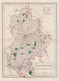
Sidney Hall 1830 [1846]
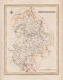
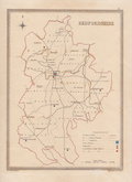
Roger Creighton 1831
Roger Creighton 1831
Gray & Son 1833
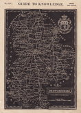
Joshua Archer 1833
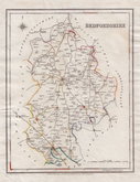
Roger Creighton 1835
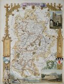
Thomas Moule 1836 [1852]
Thomas Moule 1836 [1852]


44x31 cm
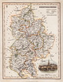
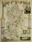
"WEEKLY DISPATCH" SERIES CASSELL EDITION
BEDFORDSHIRE
LONDON, PUBLISHED BY CASSELL, PETTER & GALPIN. LA BELLE SAUVAGE YARD, LUDGATE HILL, E.C.
Lithograph printed map engraved by Benjamin Rees Davies (c.1789-1872) first published in The Weekly Dispatch 3rd April 1859. The maps were also published as loose sheets and, when the series was complete, in The Dispatch Atlas from 1863. The publishers Cassell Petter and Galpin acquired the plates publishing them as loose sheets from 1864 and in Cassell's Illustrated family paper and Cassell's British Atlas in 1867. By 1869, the firm of G. W. Bacon had acquired the plates and published them in a number of titles for over forty years.
Good hand coloured example from the second lithographic transfer published in Cassell's British Atlas...London Cassell, Petter & Galpin 1867.
Chambers Printed Maps of Bedfordshire ref. 108B
Quick Links


Buckinghamshire Maps
Bedfordshire Prints
×