
Cheshire Maps
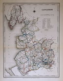
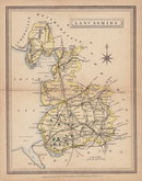
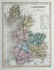
Lancashire Maps
( Page 3 of 3 )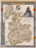
Thomas Moule 1842
Roger Creighton 1845
John Heywood 1856
Joshua Archer 1860
Francis Sidney Weller 1891

Lancashire Postcard 1975


20x27 cm
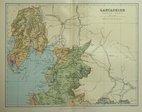
LANCASHIRE.
The maps were first issued from May 1830 in a series of parts individually bound in paper wraps. The first complete edition was published by George Virtue in 1837. Several editions followed until 1839 and the plates were then used by George Virtue and his son James Sprent Virtue in A Complete and Universal Dictionary of the English Language by the Rev. James Barclay until 1857. The engraving of the plates was shared between James Bingley, W. Schmollinger and John Dower. The plates were frequently updated to reflect the rapidly developing railway network.
Thomas Moule was born in Marylebone on January 14th 1784. He was a bookseller in Grosvenor Square between 1816 and 1822. He was inspector of 'blind letters' in the General Post Office for forty years and also held the office of Chamber-keeper of the Lord Chamberlain's department which gave him an official residence in the stable yard, St. James a lace where he spent the later years of his life and died on January 14th 1851. During his life Thomas Moule wrote a number of books on heraldry and antiquities, these interests being reflected in the decorative neo-gothic elements and coats of arms that surround his maps. It was this return to the decorative armorial cartography of the 17th and 18th centuries that contributed to the commercial success of his maps that remain popular to this day.
The Lancashire map was engraved by William Francis Schmollinger (c.1811-1869). Schmollinger was in a publishing partnership with Francis Roxburgh and James Bingley in 1833 which led to a court case betweeen Roxburgh and Schmollinger and Bingley being imprisoned for debt. Schmollinger was declared bankrupt in May 1856 and died aged 58 at Camberwell in 1869.
This example is from the 1842 edition of Barclays Dictionary . Fine later hand colour.
Quick Links
Yorkshire Maps
Westmorland Maps
×