
Cheshire Maps
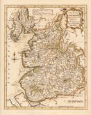
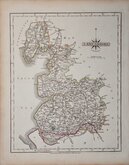
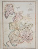
Lancashire Maps
( Page 1 of 3 )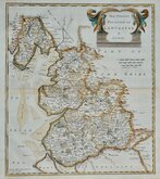
Robert Morden 1695

Emanuel Bowen 1720

Thomas Kitchin 1750 [c.1786]
Thomas Kitchin 1763
John Cary 1787 [1808]
John Cary 1789 [1805]
Henry Cooper 1808 [c.1825]

John Cary 1822


15x20 cm
HAND COLOURED LITHOGRAPH
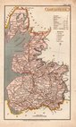
LANCASHIRE
Printed and Published by John Heywood, 170, Deansgate. Manchester.
Lithographic transfer from a copper engraved map first published by Henry Teesdale in A new travelling atlas, containing a complete set of county maps.. The whole carefully revised and corrected to the year 1830. The plate and lithographic transfers were amended many times over a period of over 30 years including a complete re-engraving of the map on a slightly larger scale, with plate number and without imprint, published by John Heywood in The Travelling Atlas of England and Wales…revised and corrected to the present time. [1868]. The final appearance of the maps were in John Heywood's county atlas of England and Wales in 1882.
This example of the map of Lancashire with the imprint of John Heywood and his 170 Deansgate address, date this issue between 1856 and 1860. Centrefold split from left margin to county boundary and two small thinned patches, repaired and strengthened verso with archival tape.
Original hand colour.
Quick Links

Yorkshire Maps

Westmorland Maps
×