
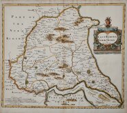
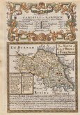
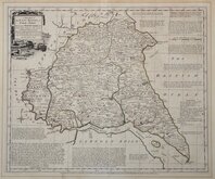
Whole of Yorkshire
Yorkshire East Riding
( Page 1 of 2 )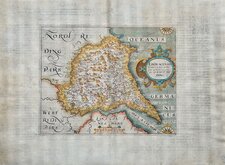
William Hole 1607
Robert Morden 1695
Emanuel Bowen 1720
Thomas Kitchin 1763 [1777]
Thomas Kitchin 1764
John Cary 1789 [1805]
Benjamin Baker 1796
George Cole 1808


11x7 cm
SCARCE MINIATURE MAP.
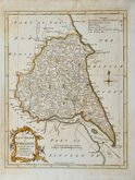
YORKSHIRE EAST RIDING
Miniature map published by John Bowyer Nichols and Son in The Family Topographer: being a compendious account of the antient and present state of the counties of England. By Samuel Tymms.
Samuel Tymms is te author of the work by which these maps are best known but they were first issued in Crosby's Complete Pocket Gazetteer of England and Wales ...London, Baldwin Cradock & Joy, 1818 [1822], and later appeared in A compendium of the Ancient and Present state of…By Samuel Tymms London, J.B.Nichols & Son [1835], The Family Topographer..by Samuel Tymms...London, J.B.Nichols & Son 1831-1837 and Camden's Britannia Epitomized..London, Henry G. Bohn, [c.1842].
The maps in Crosby's Gazetteer bear the imprint; J. Walker del. and J. Cox sc.
There is uncertainty about the identity of J. Walker, possibly John Walker (fl.1783-1831) Hydrographer to the Admiralty 1808-1831. Little is known of the engraver James Cox (fl.1815-1841), he was summoned to the Court of Insolvent Debtors on 10th July 1828 described as James Cox, map engraver, formerly of Cecil Court and a further list of about former 30 addresses. He is recorded as an engraver aged about fifty, born outside Middlesex, on the 1841 census.
The map has no scale bar. Includes distances of the major towns from London.
A scarce map.
Quick Links


Yorkshire North Riding

Yorkshire West Riding
×