
Yorkshire Maps
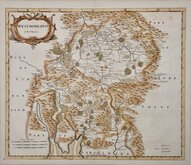
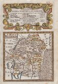
Westmorland Maps
( Page 1 of 4 )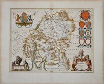
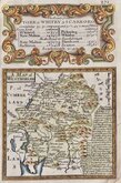
Jan Blaeu 1645
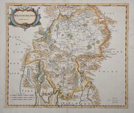
Robert Morden 1695 [1722]
Robert Morden 1695 [1753]
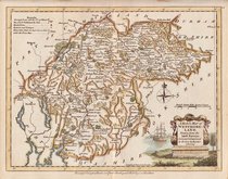
Emanuel Bowen 1720
Emanuel Bowen 1720
Joseph Ellis 1765 [1773]
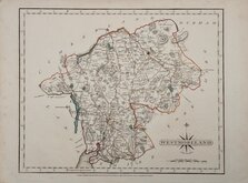
John Cary 1787
Robert Butters 1803


23x17 cm
WOOD ENGRAVING
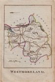
WESTMORLAND
London, Published for the Proprietors, by W.Edwards.12 Ave Maria Lane.
J.Archer.sc.
No. CXXXVIII.] PINNOCK'S GUIDE TO KNOWLEDGE PRICE ONE PENNY.
Woodblock engraved map by Joshua Archer (1792?-1863) published in weekly parts in The Guide to Knowledge edited by W Pinnock...London: W.Edwards 1833-34.
The unusual printing method whereby the engraved woodblock was inked with a roller without working the ink into the engraved cuts resulting in a white line on a black ground was not suited to to topographical maps and this is the only series of maps to use it.
The guide was re-issued in 1838 and some of the maps appeared in 1844 in (an incomplete) Descriptive county atlas of England and Wales by Groombridge Shepherd & Sutton in a revised state with a decorative border using coloured inks. The final use of the maps was by Thomas Johnson printed more conventionally by lithographic transfer from the Groombridge revised woodblocks in Johnson's Atlas of England in 1847 & 1863. The maps were noticeably out of date by this time following the rapid development of the railway network and were not popular and examples from this publication are rare.
Light overall toning but it remains a good example from The Guide to Knowledge.
Quick Links


Cumberland Maps

Lancashire Maps
×