
John Cary
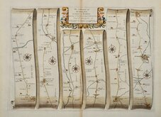
John Ogilby
( Page 1 of 5 )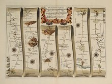
Islip - Bramyard 1675
Bramyard - Aberystwith 1675
Stamford - Newark 1675
Tuxford York 1675
York Durham 1675
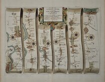
London - Dover 1675
Newcastle - Berwick 1675
London - St.Davids Set of 4 Maps 1675


45x35 cm
The Roads from SHREWSBURY and CHESTER to HOLYWELL com FLINT. By JOHN OGILBY Esq:r His Ma.ties Cosmographer …
Complete route from Shrewsbury to Holywell showing Shrewsbury, Battlefield, Harmer Hill, Myddle, Burlton, Cockshutt, Oteley, Ellesmere, Trench, Overton, Marchweil, Wrexham, Caergwle, Hope, Mold, Rhosesmor, Holywell, and separate route from Chester to Holywell showing Chester, Harwarden, Flint, Holywell.
A fine map from the first edition of 1675 without plate number, later numbered 98 to assist the binder. Generous margins, undamaged and unrestored in fine later hand colour.
Includes original page of text description of the route.
For more information on Ogilby and his work see description under the category heading.
Quick Links

Owen & Bowen
Roads by other Mapmakers
×