
John Cary
John Ogilby
( Page 1 of 5 )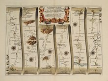
Islip - Bramyard 1675
Bramyard - Aberystwith 1675
Stamford - Newark 1675
Tuxford York 1675
York Durham 1675
London - Dover 1675
Newcastle - Berwick 1675
London - St.Davids Set of 4 Maps 1675


45x31 cm
FIRST ISSUE. WAYWISER CARTOUCHE.
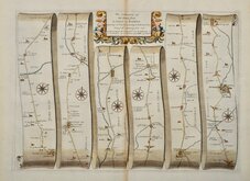
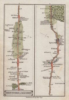
The Road from LONDON to Holyhead co Anglesey North Wales. actually Survey'd and Delineated, By IOHN OGILBY Esqr. His Maties. Cosmographer...
The first part of the route from London to Holyhead showing:
Southwark, Lambeth, London, Pinder of Wakefield Inn, New River Head, Islington, Jack Straws Castle pub, Kentish Town, Holloway, Highgate, Finchley, Friern Barnet, Totteridge, Whetstone, East Barnet, High Barnet, Monken Hadley, Enfield Chase, Kitts End, South Mimms, North Mymms, Ridge, London Colney, Napsbury, St Albans, Childwickbury, Redbourn, Flamstead, Markyate, Kensworth, over page Dunstable, Houghton Regis, Chalk Hill, Sewell, Thorn, Tilsworth, Tebworth, Hockliffe, Battlesden, Heath and Reach, Little Brickhill, Bow Brickhill, Fenny Stratford, Simpson, Bletchley, Shenley Church End, Loughton, Upper Weald, Middle Weald, Lower Weald, Stony Stratford, Old Stratford, Potterspury, Alderton, Paulerspury, Heathencote, Towcester.
First state of the plate without plate number issued 1675. Susequently numbered 21.
Very fine example with generous margins. Strong paper with fleur-de-lis watermark. Fine later hand colour. Includes original typeset text description of the road.
One of the three plates in the work to include the highly decorative Waywiser title cartouche.
For more information on Ogilby and his work see category heading.
Quick Links

Owen & Bowen
Roads by other Mapmakers
×