
Ordnance Survey Maps
Folding Maps
( Page 1 of 18 )
Bowles. England & Wales. 1811

Thomas Dix Derbyshire. 1818

Thomas Dix. Yorkshire. 1820

Hebner & Phillips. South East 1821

Henry Teesdale Yorkshire 1828
Robert Seaton. England & Wales 1838

Hobson's Yorkshire 1843

Stephen Glover 1845


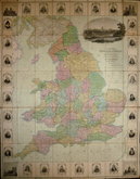
£350 Robert Seaton. England & Wales
Ref: 6074Wx
Add to
basket
Thanks,Your Product Has Been Added To Basket

106x98 cm
THIS NEW MAP OF | ENGLAND & WALES, | COMPILED FROM | The Latest Surveys, | IS RESPECTFULLY DEDICATED | TO THE QUEEN, | By Her Majesty's | MOST OBEDIENT SERVANT, ROBERT SEATON | Engraved and Published for the Proprietor by J&C Walker 9, Castle Strt Holborn.
Decorative large folding wall map segmented and linen backed. Original hand colour to map. Surrounded by 28 portraits of British worthies with vignettes in each corner of Canterbury Cathedral, York Minster, Westminster Abbey and St. Paul's Cathedral. Large vignette of Windsor Castle over title.
First issued c.1835 with dedication to William IV, this example has dedication amended to Queen Victoria.
Folds a little fragile with some splitting to linen in places, creasing to edges outside printed area. Lacks slipcase. A good example of a large decorative map.
Quick Links

English Counties

Regional Maps
×