
Regional Maps
Folding Maps
( Page 1 of 18 )
Bowles. England & Wales. 1811

Thomas Dix Derbyshire. 1818

Thomas Dix. Yorkshire. 1820

Hebner & Phillips. South East 1821

Henry Teesdale Yorkshire 1828
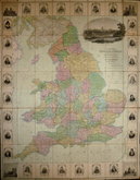
Robert Seaton. England & Wales 1838

Hobson's Yorkshire 1843

Stephen Glover 1845


67x53 cm
Half Inch Mp of England. Cheltenham and Gloucester Section (sheet25).
Published by Gall & Inglis, Edinburgh & London 25 Paternoster Square.
Scale: 1 Inch = 2 miles.
Cloth backed with pasted card covers. Overprinted in brown. Good condition throughout.
Seller's label to cover: Jesse J. Gillingham & Son, Wholesale Stationers Printers and Bookbinders. Fancy Goods dealers. 369 Hgh Street Cheltenham.
Quick Links

English Counties

Ordnance Survey Maps
×